Ho Chi Minh City Administrative Map with 22 Districts
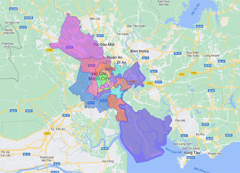
Ho Chi Minh City is the country’s leading economic center and has undergone continuous development and transformation over the years. The Ho Chi Minh City map is one of the useful tools that helps us clearly see changes in the urban landscape as well as the city’s future development potential. In this article, Maison Office will share with you the city map. Ho Chi Minh and the latest map of Saigon districts today!
Table of Contents
- 1. Introduction to Ho Chi Minh City
- 2. Administrative map of Ho Chi Minh City
- 3. Administrative map of districts in Ho Chi Minh City
- 3.1. District 1 map
- 3.2. District 2 map
- 3.3. District 3 map
- 3.4. District 4 map
- 3.5. District 5 map
- 3.6. District 6 map
- 3.7. District 7 map
- 3.8. District 8 map
- 3.9. District 9 map
- 3.10. District 10 map
- 3.11. District 11 map
- 3.12. District 12 map
- 3.13. Map of Binh Tan district
- 3.14. Map of Thu Duc city
- 3.15. Map of Tan Phu district
- 3.16. Map of Tan Binh district
- 3.17. Map of Phu Nhuan district
- 3.18. Map of Go Vap district
- 3.19. Map of Binh Thanh district
- 3.20. Map of Binh Chanh district
- 3.21. Map of Can Gio district
- 3.22. Map of Cu Chi district
- 3.23. Map of Hoc Mon district
- 3.24. Map of Nha Be district
- 4. Map of office buildings in Ho Chi Minh City
1. Introduction to Ho Chi Minh City
Ho Chi Minh (also known as Saigon) is one of the largest cities in Vietnam. This place is considered the most important economic – cultural – social – educational center in the country. In recent years, Ho Chi Minh City has shown strong development and outstanding economic growth. This is followed by the development of the urban landscape, helping the city change its appearance to become more civilized and modern.
1.1. Geographical location
Ho Chi Minh City is a centrally run city, classified as a special urban area of Vietnam along with the capital Hanoi. The area of Ho Chi Minh City is 2,095 km2, including mostly mainland area and a number of small islands stretching on the Saigon River and Dong Nai River.
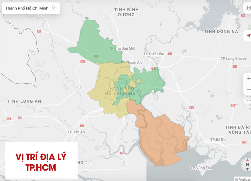
On the map of Vietnam, Ho Chi Minh City is geographically located in the South of our country, in the transition zone between the Southeast and the Mekong Delta. The exact geographical coordinates on the HCM map are 10°10′ – 10°38′ North and 106°22′ – 106°54′ East. The extreme points of Ho Chi Minh City are specifically as follows:
- The northernmost point of Ho Chi Minh City is located in Phu My Hung commune, Cu Chi district.
- The southernmost point of Ho Chi Minh City is located at: Long Hoa commune, Can Gio district.
- The westernmost point of Ho Chi Minh City is located at: Thai My commune, Cu Chi district.
- The easternmost point of Ho Chi Minh City is located at: Thanh An commune, Can Gio district.
1.2. Population density
According to a report from the Department of Health, as of June 1, 2023, Ho Chi Minh City has a total population of nearly 8.9 million people (the specific number is 8,899,866 people). Ho Chi Minh City’s population density also leads the country, at about 4,248 people/km2. If including cases of residence without household registration, the actual population of the entire city can be up to 14 million people.
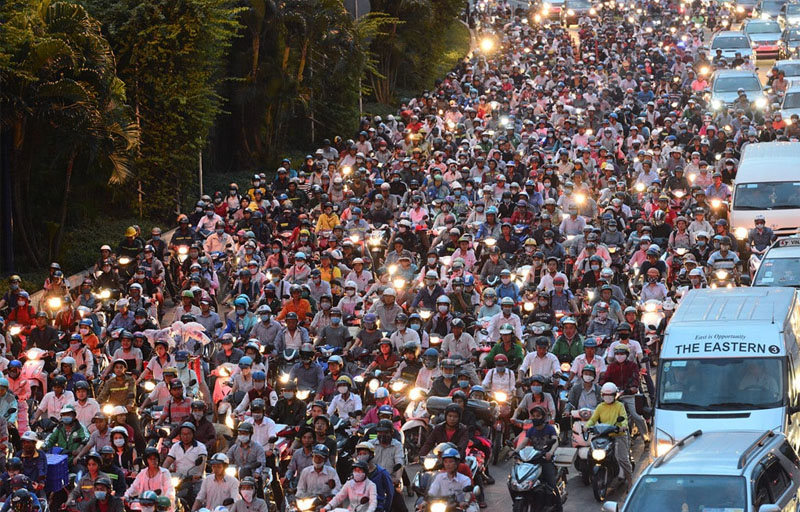
Of which, the population in urban areas accounts for about 79% of the entire city’s population (about more than 7 million people). The remaining 21% is the proportion of the population living in rural areas (about more than 1.9 million people). It can be seen that the population distribution in Ho Chi Minh City has a clear difference. Specifically, the population is mainly concentrated in the central districts of the city, while suburban areas such as Can Gio district often have few residents.
In the past few years, population density in central districts has tended to decrease. Instead, the population in suburban districts tends to increase due to affordable costs and living standards, suitable for immigrants from many other provinces and cities to live and work in Ho Chi Minh City.
2. Administrative map of Ho Chi Minh City
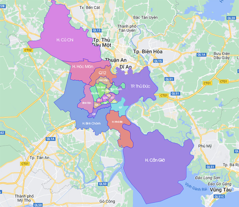
Based on the administrative map of Ho Chi Minh City in 2023, the city’s administrative boundaries are divided into: City. Thu Duc, 16 districts and 5 districts (Nha Be, Hoc Mon, Binh Chanh, Can Gio, Cu Chi). Below are 312 commune-level administrative units, including: 249 wards, 58 communes and 5 towns directly under the city. HCM.
| Administrative units | Area (km2) 2020 | Number of wards and communes | Population 2020 |
| District 1 | 7,73 | 10 wards | 142.625 |
| District 3 | 4,92 | 12 wards | 190.375 |
| District 4 | 4,18 | 13 wards | 175.329 |
| District 5 | 4,27 | 14 wards | 159.073 |
| District 6 | 7,14 | 14 wards | 233.561 |
| District 7 | 35,69 | 10 wards | 360.155 |
| District 8 | 19,11 | 16 wards | 424.667 |
| District 10 | 5,72 | 14 wards | 234.819 |
| District 11 | 5,14 | 16 wards | 209.867 |
| District 12 | 52,02 | 11 wards | 620.146 |
| Binh Thanh district | 20,78 | 20 wards | 499.164 |
| Go Vap district | 19,73 | 16 wards | 676.899 |
| Phu Nhuan district | 4,88 | 13 wards | 163.961 |
| Tan Binh district | 22,43 | 15 wards | 474.792 |
| Tan Phu district | 15,97 | 11 wards | 485.348 |
| Binh Tan district | 52,02 | 10 wards | 784.173 |
| Thu Duc city | 211,56 | 34 wards | 1.169.967 |
| Nha Be district | 100,43 | 1 town, 6 communes | 206.837 |
| Hoc Mon district | 109,17 | 1 town, 11 communes | 542.243 |
| Binh Chanh district | 252,56 | 1 town, 15 communes | 705.508 |
| Cu Chi district | 434,77 | 1 town, 20 communes | 462.047 |
| Can Gio district | 704,45 | 1 town, 6 communes | 71.526 |
3. Administrative map of districts in Ho Chi Minh City
As of 2020, Ho Chi Minh City has a total of 22 administrative units. This includes 1 city (Thu Duc City), 16 districts and 5 districts, only District 2 and District 9 were previously merged into the City. Thu Duc. The map of Ho Chi Minh City districts will be a useful tool to help provide complete information about each administrative unit in the city.
Below is the most detailed map of Ho Chi Minh City districts:
3.1. District 1 map
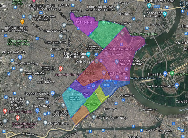
District 1 is one of the central districts of Ho Chi Minh City, considered the economic, financial, cultural and social center of the city. This administrative unit has a total natural area of 7.72 km2, divided into 10 wards including: Ben Thanh, Ben Nghe, Da Kao, Nguyen Cu Trinh, Nguyen Thai Binh, Tan Dinh, Co Giang, Cau Ong Lanh, Pham Ngu Lao, Cau Kho.
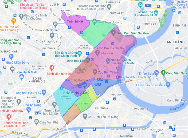
According to the 2020 census data, District 1 of Ho Chi Minh City has a population of about 142,625 people, with a population density of 18,475 people/km2. The specific geographical location on the Ho Chi Minh map is as follows:
- The east of District 1 borders Thu Duc city.
- The west borders District 3 and District 5.
- The south borders District 4.
- The North borders Phu Nhuan and Binh Thanh districts.
>> See more: Office buildings for rent in District 1
3.2. District 2 map
District 2 is an administrative unit located in the northeast of the city, known as one of the fastest growing districts. District 2 is located on the east bank of the Saigon River, connected to District 1 by many famous bridges such as Saigon Bridge, Thu Thiem Bridge and Phu My Bridge. This location advantage has created favorable conditions for moving between District 2 and key areas of the city.
District 2 is famous for Thu Thiem new urban area – a modern urban center project with many high-rise buildings, parks, commercial areas and diverse amenities. That’s why this area has the potential to grow very quickly, real estate prices also increase sharply and continuously.
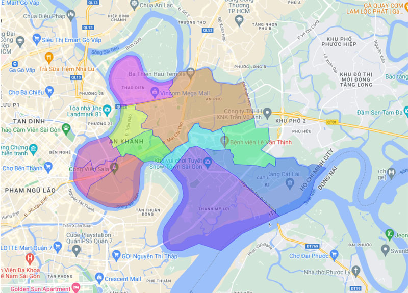
In 2020, District 2 was merged with District 9 and Thu Duc District to become City. Thu Duc. But before that, the District 2 area was divided into 11 wards including: An Khanh, An Phu, An Loi Dong, Binh An, Binh Khanh, Binh Trung Tay, Binh Trung Dong, Cat Lai, Thanh My Loi, Thu Thiem , Thao Dien.
>> See more: Office buildings for rent in District 2
3.3. District 3 map
District 3 is also the central district of Ho Chi Minh City, adjacent to District 1 and District 10, known as the home to many embassies of countries. This area includes important traffic routes of the city such as: Cach Mang Thang Tam, Le Van Sy, Nguyen Thi Minh Khai,… helping to easily connect with other areas in the city.
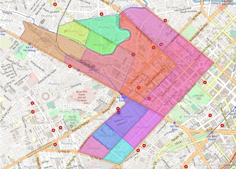
Currently, District 3 administrative unit has 12 wards, specifically including: wards 1, 2, 3, 4, 5, 9, 10, 11, 12, 13, 14 and Vo Thi Sau. Accordingly, the previous wards 6, 7, and 8 were merged into Vo Thi Sau ward in January 2021.
>> See more: Office buildings for rent in District 3
3.4. District 4 map
District 4 has a special location on the southern bank of the Saigon River, connected to District 1 via Calmette Bridge or Ong Lanh Bridge. With an area of 4.18km2, this is considered the smallest district in Ho Chi Minh City, surrounded by a system of rivers and canals. With its location on the banks of the Saigon River, District 4 has a series of wharves, marinas and seaport areas such as Cau Da port and Khanh Hoi port.
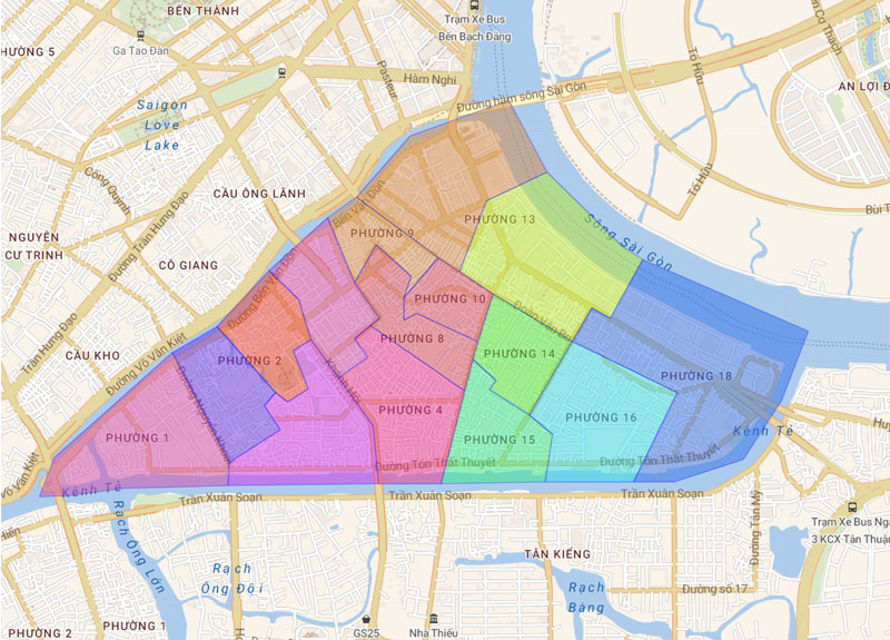
In recent years, District 4 has undergone a major transformation with many urban development projects and skyscraper construction. In particular, the western area of the district is home to many high-end apartment projects and office buildings. The current District 4 administrative map includes 13 wards: 1, 2, 3, 4, 6, 8, 9, 10, 13, 14, 15, 16, 18.
>> See more: Office buildings for rent in District 4
3.5. District 5 map
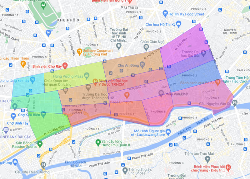
District 5 (also known as “Cho Lon”) is located in the center of the Ho Chi Minh City map, adjacent to District 1, District 10, District 11 and District 6. This is where the residential community concentrates. Flowers in Saigon. When looking on the map of Saigon, you can see many pagodas, temples, shrines and architectural works imbued with cultural identity. Currently, District 5 administrative unit includes 14 wards: 1, 2, 3, 4, 5, 6, 7, 8, 9, 10, 11, 12, 13, 14.
>> See more: Office buildings for rent in District 5
3.6. District 6 map
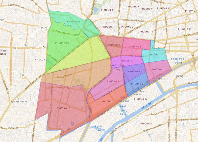
District 6 is located in the west of Ho Chi Minh City center, bordering District 5, District 8, District 11, Binh Tan District and Tan Phu District. On the map of Ho Chi Minh City districts, this is the largest concentration of the Chinese community, bringing population and cultural diversity to the city. District 6 area includes 14 wards: 1, 2, 3, 4, 5, 6, 7, 8, 9, 10, 11, 12, 13, 14.
3.7. District 7 map
District 7 is one of the strongly developed districts, located in the south on the administrative map of Ho Chi Minh City. In terms of administrative units, District 7 is divided into 10 wards including: Phu My, Phu Thuan, Binh Thuan, Tan Phong, Tan Phu, Tan Hung, Tan Kieng, Tan Quy, Tan Thuan Dong, Tan Thuan Tay.
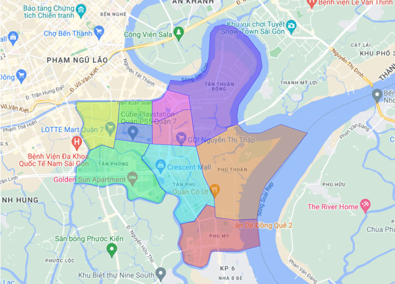
The most prominent feature of District 7 is Phu My Hung urban area – a top destination for the rich and the foreign community (mostly Korean).
>> See more: Office buildings for rent in District 7
3.8. District 8 map
District 8 is located in the southwest of Saigon, including 16 wards: 1, 2, 3, 4, 5, 6, 7, 8, 9, 10, 11, 12, 13, 14, 15, 16. Located between Saigon River and Dong Nai River, District 8 inherits a unique geographical position and borders the following districts: District 5, District 7, District 4 and Nha Be district.
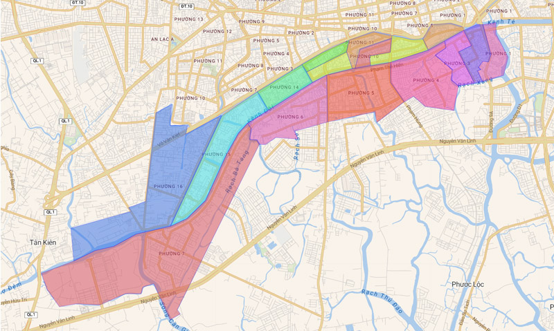
>> See more: Office buildings for rent in District 8
3.9. District 9 map
In the East of the Ho Chi Minh City map is District 9, located quite far from the center, adjacent to the Dong Nai River. This area is home to high-tech parks and many big corporate names such as Samsung and Intel. Outstanding traffic features are Metro Ben Thanh – Suoi Tien, Long Thanh – Dau Giay expressway, new Mien Dong bus station,…
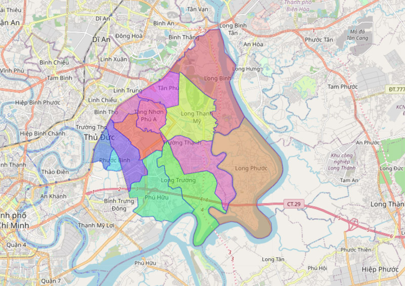
Administrative unit of District 9 before merging into City. Thu Duc is 13 wards, including: Long Binh, Long Truong, Long Phuoc, Hiep Phu, Long Thanh My, Phu Huu, Phuoc Binh, Tan Phu, Tang Nhon Phu A, Tang Nhon Phu B, Truong Thanh, Phuoc Long A , Phuoc Long B.
3.10. District 10 map
Referring to the central districts of Ho Chi Minh City, it is impossible not to mention District 10, located adjacent to District 3, District 5, District 11 and Tan Binh District. District 10 administrative unit on the city map. Ho Chi Minh includes 14 wards: 1, 2, 4, 5, 6, 7, 8, 9, 10, 11, 12, 13, 14, 15.
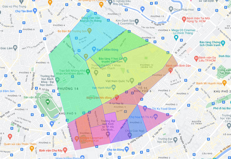
>> See more: Office buildings for rent in District 10
3.11. District 11 map
District 11 is home to many Chinatowns and diverse cultures. The geographical location on the Ho Chi Minh City district map is the west of the city, adjacent to neighboring districts such as District 5, District 6, District 10 and Tan Binh District. District 11 administrative unit includes 16 wards: 1, 2, 3, 4, 5, 6, 7, 8, 9, 10, 11, 12, 13, 14, 15, 16.
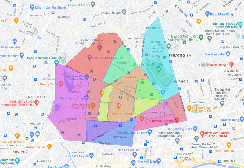
>> See more: Office buildings for rent in District 11
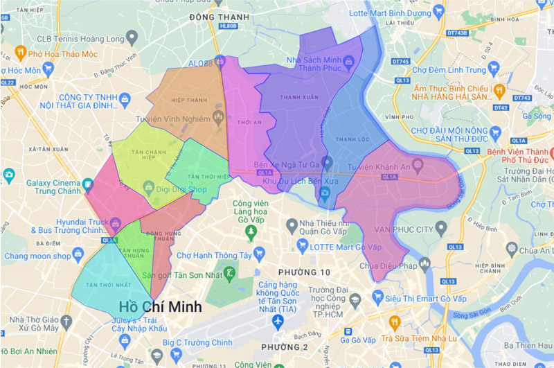
3.12. District 12 map
The map of District 12 shows that this area is located north of the city, quite far from the center. There are many major roads crossing here including: National Highway 1A, National Highway 22 and many other provincial roads. District 12 is currently divided into 11 wards, including: An Phu Dong, Dong Hung Thuan, Tan Hung Thuan, Hiep Thanh, Thoi An, Tan Thoi Nhat, Tan Thoi Hiep, Tan Chanh Hiep, Thanh Loc, Thanh Xuan, Trung American West.
>> See more: Office buildings for rent in District 12
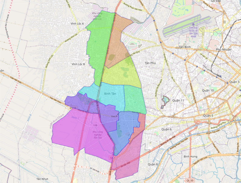
3.13. Map of Binh Tan district
Binh Tan District is located in the west of Ho Chi Minh City map, has a fairly dense population of about 784,173 people, and a population density of about 15,047 people/km2. The administrative map of Binh Tan district includes 10 wards: An Lac, An Lac A, Binh Hung Hoa, Binh Hung Hoa A, Binh Hung Hoa B, Tan Tao, Tan Tao A, Binh Tri Dong A, Binh Tri Dong B.
3.14. Map of Thu Duc city
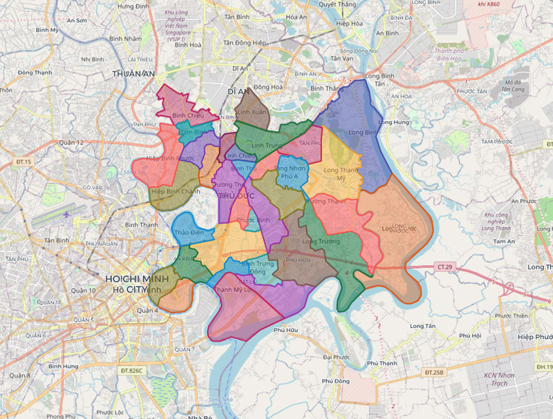
Thu Duc City was officially established in January 2022 on the basis of merging 3 districts: District 2, District 9 and Thu Duc district. This is the first city in our country in the type of administrative unit that is a city under central government.
After officially merging, the administrative unit of City. Thu Duc has 34 wards, specifically: An Khanh, An Phu, An Loi Dong, Binh Chieu, Binh Tho, Binh Trung Dong, Binh Trung Tay, Hiep Phu, Hiep Binh Chanh, Hiep Binh Phuoc, Cat Lai, Linh Trung , Linh Xuan, Linh Tay, Linh Dong, Long Phuoc, Long Binh, Long Truong, Long Thanh My, Phu Huu, Phuoc Binh, Phuoc Long A, Phuoc Long B, Tam Phu, Tam Binh, Tang Nhon Phu A, Tang Nhon Phu B, Tan Phu, Thanh My Loi, Thao Dien, Thu Thiem, Truong Thanh, Truong Tho.
>> See more: Office buildings for rent in Thu Duc City
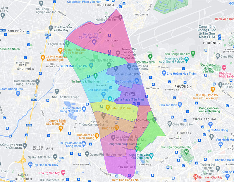
3.15. Map of Tan Phu district
Tan Phu District has an area of 15.97 km2 with a fairly large population (about 485,348 people). The district administrative unit includes 11 wards: Hoa Thanh, Phu Thanh, Hiep Tan, Phu Trung, Phu Tho Hoa, Son Ky, Tan Quy, Tan Son Nhi, Tan Thanh, Tan Thoi Hoa, Tay Thanh. With the advantage of location and development potential, Tan Phu district has become a destination for many residents to settle down and start a business.
>> See more: Office buildings for rent in Tan Phu District
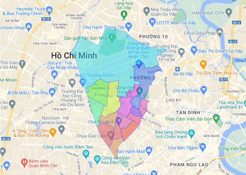
3.16. Map of Tan Binh district
Tan Binh District is located adjacent to District 3, District 10, District 12, Phu Nhuan District and Go Vap District. The area of this area is 22.43km2 and the population is about 474,792 people, divided into 15 wards: 1, 2, 3, 4, 5, 6, 7, 8, 9, 10, 11, 12, 13, 14, 15.
>> See more: Office buildings for rent in Tan Binh District
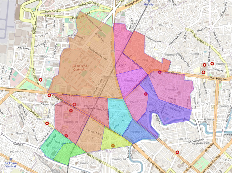
3.17. Map of Phu Nhuan district
On the map of Ho Chi Minh City districts, Phu Nhuan district has a quite small area, only 4.86 km2 and is divided into 13 wards: 1, 2, 3, 4, 5, 7, 8, 9, 10, 11, 13, 15, 17. This area is located adjacent to central districts such as District 1, District 3, Tan Binh, Binh Thanh and Go Vap districts, convenient for movement and connection.
>> See more: Office buildings for rent in Phu Nhuan District
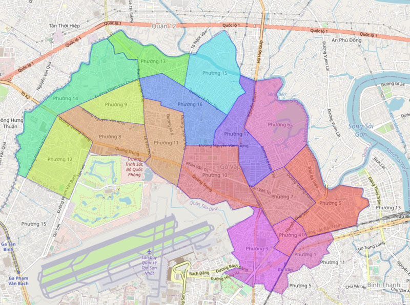
3.18. Map of Go Vap district
Go Vap District is located in the north of the city, adjacent to District 12, Tan Binh, Phu Nhuan and Binh Thanh districts. The area of Go Vap district is about 19.73 km2, divided into 16 wards including: 1, 3, 4, 5, 6, 7, 8, 9, 10, 11, 12, 13, 14, 15, 16, 17. In particular, Ward 10 is where the headquarters of the People’s Committee and other administrative agencies are located.
>> See more: Office buildings for rent in Go Vap District
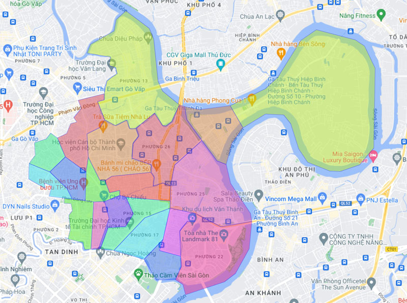
3.19. Map of Binh Thanh district
Binh Thanh District has a natural area of 20.78 km2, divided into 20 wards including: 1, 2, 3, 5, 6, 7, 11, 12, 13, 14, 15, 17, 19, 21, 22 , 24, 25, 26, 27, 28. The population density of this area is quite high, about 24,021 people/km2 (population is 499,164 people).
>> See more: Office buildings for rent in BInh Thanh District
3.20. Map of Binh Chanh district
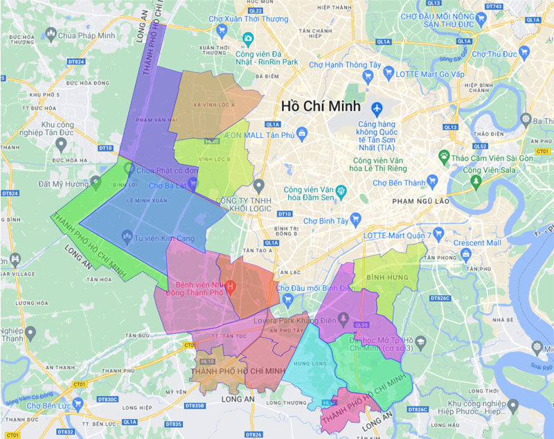
Binh Chanh district has a quite large natural area of about 252.56 km2. It includes 16 administrative units including 1 town (Tan Tuc) and 15 communes (An Phu Tay, Binh Hung, Binh Chanh, Binh Loi, Da Phuoc, Hung Long, Le Minh Xuan, Pham Van Hai, Phong Phu , Quy Duc, Tan Kien, Tan Nhut, Tan Quy Tay, Vinh Loc A, Vinh Loc B).
3.21. Map of Can Gio district
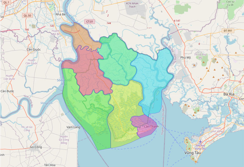
Can Gio district is known as the only district of Ho Chi Minh City bordering the sea, about 50km southeast of the city center. The natural area of Can Gio district is 704.45 km2, divided into 7 administrative units. It includes 1 town (Can Thanh) and 6 communes (An Thoi Dong, Binh Khanh, Long Hoa, Ly Nhon, Tam Thon Hiep, Thanh An).
3.22. Map of Cu Chi district
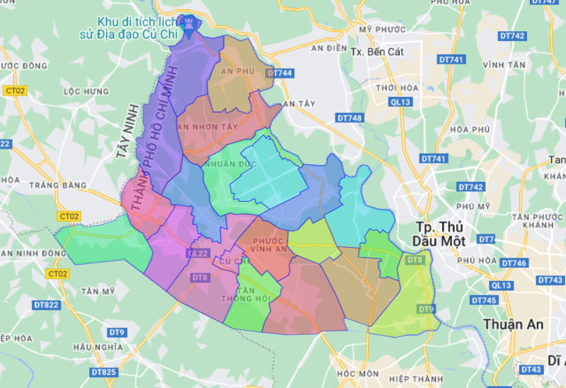
Cu Chi district has a natural area of 434.77 km2, divided into 1 Cu Chi town and 20 communes (An Nhon Tay, An Phu, Binh My, Hoa Phu, Nhuan Duc, Phu Hoa Dong, Pham Van Coi, Phu My Hung, Phuoc Thanh, Phuoc Hiep, Phuoc Vinh An, Tan An Hoi, Tan Phu Trung, Tan Thong Hoi, Tan Thanh Dong, Tan Thanh Tay, Thai My, Trung An, Trung Lap Upper, Trung Lap Ha).
3.23. Map of Hoc Mon district
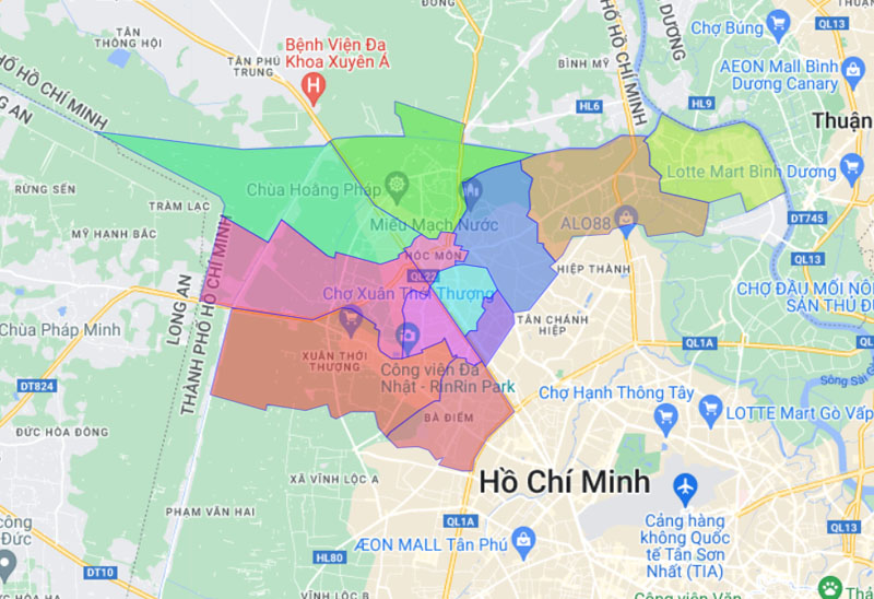
Hoc Mon district is located in the northwest on the map of Ho Chi Minh City. The natural area of the district is 109.17 km2, divided into 12 administrative units. It includes 1 town (Hoc Mon) and 11 communes (Ba Diem, Nhi Binh, Dong Thanh, Tan Hiep, Tan Xuan, Tan Thoi Nhi, Thoi Tam Thon, Trung Chanh, Xuan Thoi Thuong, Xuan Thoi Dong, Xuan Thoi Paint).
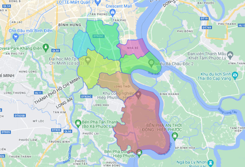
3.24. Map of Nha Be district
Nha Be district is located in the southeast of Ho Chi Minh City, with a natural area of 100.43 km2. This area is divided into 7 administrative units, including 1 town (Nha Be) and 6 communes (Hiep Phuoc, Long Thoi, Nhon Duc, Phu Xuan, Phuoc Loc, Phuoc Kien).
4. Map of office buildings in Ho Chi Minh City
Ho Chi Minh City has over 1,500 office buildings available for lease, with a concentrated distribution in central districts and emerging areas such as Thu Duc City and District 7. The office rental market in Ho Chi Minh City continues to grow, with numerous new projects being launched to meet the increasing demand from both domestic and international businesses.
From the information provided, you have likely gained a comprehensive understanding of the map of Saigon as well as the detailed maps of each district. Along with continuous changes, the map of Ho Chi Minh City also highlights many opportunities and challenges that the city will face in the future. We hope this article has provided you with valuable and useful insights.


