World Map: World Atlas & Geographic Information
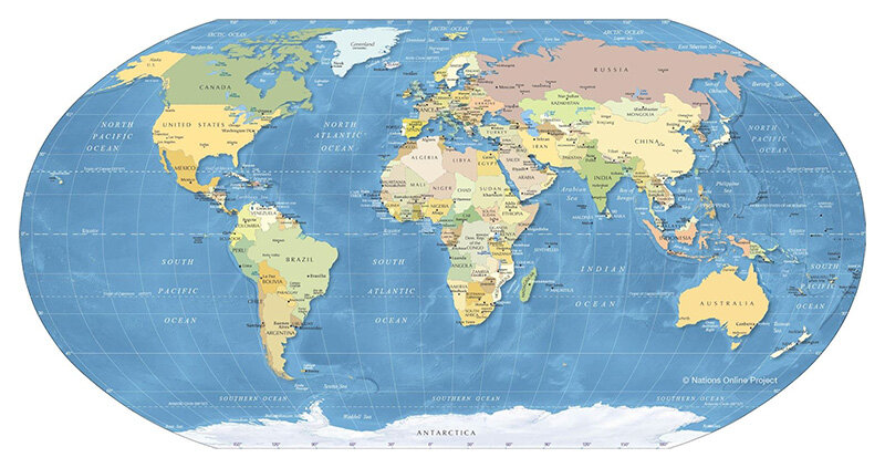
The world map is not merely a drawing but a valuable tool for exploring the planet we call our ‘common home.’ Today, one can easily find various types of maps, ranging from comprehensive world maps to those focused on individual continents and countries. All of these maps play a significant role in enhancing our understanding of geography, culture and the development of nations worldwide.
Table of Contents
1. World Map
A world map is a scaled-down and relatively accurate representation of the Earth’s entire surface, visually depicting countries, territories, borders, topography, population distribution, transportation networks and various other information.
| Physical characteristics of the Earth | |
| Total surface area | 510,000,000 km² (196,950,000 square miles) |
| Land area | 149,000,000 km² (57,510,000 square miles) |
| Water area | 361,000,000 km² (40,077 km or 24,902 miles) |
| Circumference at the equator | 40,009 km (24,860 miles) |
| Polar circumference | 40,009 km (24,860 miles) |
| Diameter at the equator | 12,757 km (7,926 miles) |
| Diameter measured from pole to pole | 12,714 km (7,899.988 miles) |
| Volume of the Earth | 1,080,000,000,000 km³ (260,000,000,000 cubic miles) |
| Mass | 5,980,000,000,000,000,000,000 tons (6,592,000,000,000,000,000,000 long tons) |
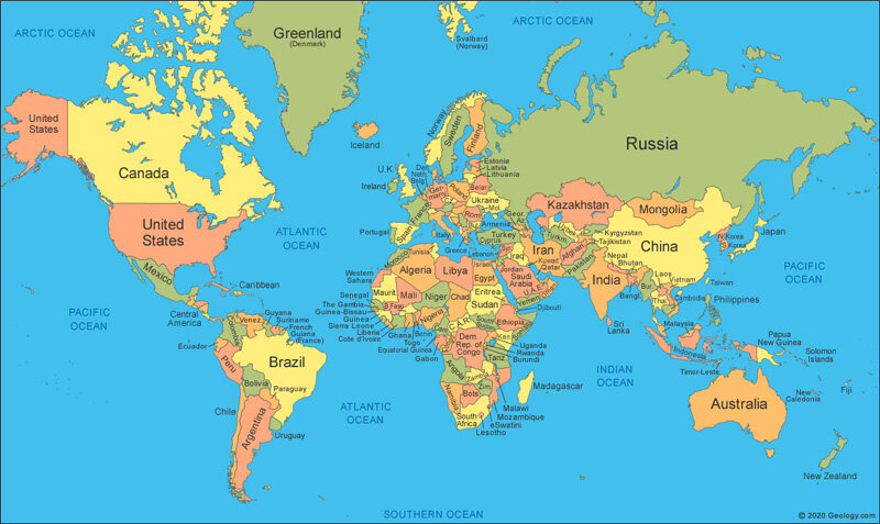
The Earth currently has an area of 510.1 million km², of which the land accounts for approximately 29.2% (148.9 million km²), divided into six continents as follows:
- Asia with an area of 44,580,000 km²
- Europe with an area of 10,180,000 km²
- Africa with an area of 30,370,000 km²
- America with an area of 42,550,000 km²
- Oceania with an area of 8,526,000 km²
- Antarctica with an area of 14,000,000 km²
In the United States, the continent of America is further divided into two parts: South America and North America. Therefore, they also consider the Earth to have seven continents. These continents are classified into five landmasses: Eurasia, America, Australia and Antarctica.
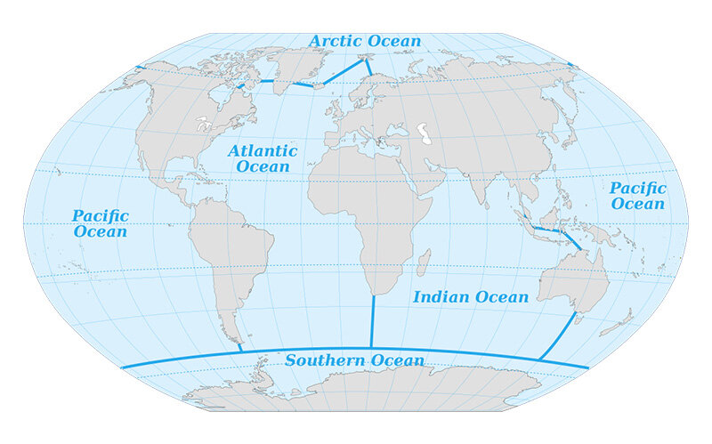
The remaining 70.8% of the Earth’s total surface area is covered by oceans (312,369,000 km²). This body of water is divided into five major oceans, including:
| Ocean | Area (km2) |
| Pacific | 161.800.000 km2 |
| Atlantic | 106.500.000 km2 |
| Indian Ocean | 70.560.000 km2 |
| Arctic Ocean | 14.060.000 km2 |
| southern Ocean | 20.330.000 km2 |
An interesting fact is that the Southern Ocean was only officially recognized on June 8, 2021, coinciding with World Oceans Day. This fifth ocean is defined by oceanic currents rather than geographical locations and tectonic plates, as with the previous four oceans. The recognition of the Southern Ocean on the world map will significantly impact educational programs and geographical scientific research.
2. The Map of 6 Continents in the World
As mentioned earlier, the Earth is divided into six major continents: Asia, Europe, Africa, America, Oceania, Antarctica. A map of the continents will play a crucial role in providing an overview of the shape and area of each continent, as well as other significant geographical features.
2.1. The Map of Asia
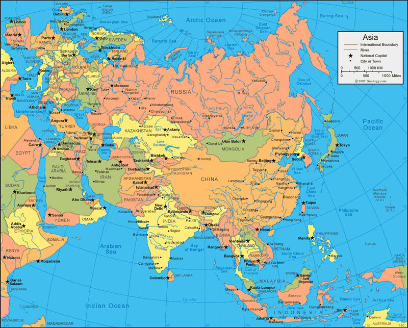
Asia is located in the eastern part of the Eurasian continent and comprises 55 countries and territories. Among these, there are 48 independent countries and 7 territories (Taiwan, Hong Kong, Macau, Abkhazia, Nagorno-Karabakh, South Ossetia, the British Indian Ocean Territory). The Asian countries are divided into six geographical regions, each with distinct geographical and cultural characteristics:
- East Asia: This region includes five countries: China, South Korea, North Korea, Japan, Mongolia. Notably, China, South Korea, Japan are among the countries with remarkable economic development.
- West Asia: This area comprises 19 countries, including Iran, Turkey, Jordan, known for its vast and diverse oil and gas resources.
- Southeast Asia: This region consists of 11 countries, including Vietnam, Thailand, Indonesia, recognized for its unique and diverse cultural heritage.
- Central Asia: Located in the heart of the continent, this region encompasses five countries (Kazakhstan, Uzbekistan, etc.) and is renowned for its natural resources such as crude oil and minerals.
- South Asia: This region includes nine countries (India, Afghanistan, Sri Lanka, etc.). Bhutan is known as the “Land of Happiness,” while the Maldives is famous for its stunning island landscapes.
- North Asia: This sub-region includes the Asian part of Russia, characterized by its vast area and diverse terrain.
Another noteworthy aspect of this continent is its strategic location, bordered by the Pacific Ocean to the east, the Arctic Ocean to the north, the Indian Ocean to the south, which provides significant advantages for this region.
2.2. Map of Africa
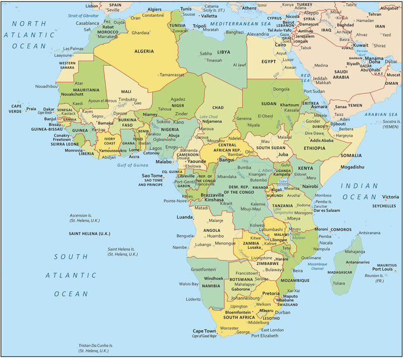
According to data from the United Nations, Africa’s population as of October 2023 is approximately 1.4 billion people, accounting for 17.8% of the world’s total population. This region is known for its rich history, with traces of humanity dating back to prehistoric times. Additionally, Africa is home to a diverse array of cultures, comprising numerous countries and ethnic groups. Below are the geographical regions on the map of the African continent:
| African geographical region | Countries |
| East Africa | Burundi, Kenya, Mozambique, Rwanda, Tanzania, Uganda. |
| Northeast Africa | Djibouti, Eritrea, Ethiopia, Somalia, Somaliland, Sudan, Nam Sudan. |
| Central Africa | Angola, Cameroon, Cong hoa Congo, Cong hoa Dan chu Congo, Cong hoa Trung Phi, Gabon, Tchad, Zambia. |
| North Africa | Algerie, Ai Cap, Libya, Morocco, Mauritania, Tunisia. |
| South Africa | Botswana, Lesotho, Malawi, Namibia, Cong hoa Nam Phi, Eswatini, Zimbabwe |
| west African | Benin, Burkina Faso, Bo Bien Nga, Gambia, Ghana, Guinea Xich Dao, Guinee, Guine – Bissau, Liberia, Mali, Niger, Nigeria, Senegal, Sierra Leone, Togo |
In addition to providing information about the geographical location of countries, the map of Africa also helps readers learn more about the climate and terrain characteristics of this region. The climate in Africa is also very diverse, ranging from harsh, arid deserts to cool, tropical rainforests.
2.3. Map of Europe
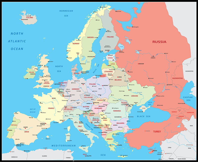
With an area of 10,600,000 km², Europe is the second smallest continent in the world, surpassed only by Oceania. As of October 2023, its population is approximately 746.8 million people (according to United Nations data), representing about 10.6% of the global population. The natural boundary between the continents of Europe and Asia is marked by the Ural Mountains, which extend for 2,500 kilometers.
| LIST OF INDEPENDENT COUNTRIES IN EUROPE | |||
| Albania | Finland | Luxembourg | Russia |
| Andorra | France | Malta | San Marino |
| Austria | Germany | Moldova | Serbia |
| Belarus | Greek | Monaco | Slovakia |
| Belgium | Hungary | Montenegro | Slovenia |
| Portugal | Iceland | Netherlands | Spain |
| Bosnia and Herzegovina | Republic of Ireland | North Macedonia | Sweden |
| Bulgaria | Italy | Norway | Switzerland |
| Croatia | Latvia | Poland | Vatican City |
| Czech Republic | Liechtenstein | Romania | Ukraina |
| Denmark | Litva | Estonia | UK |
2.4. Map of the Americas
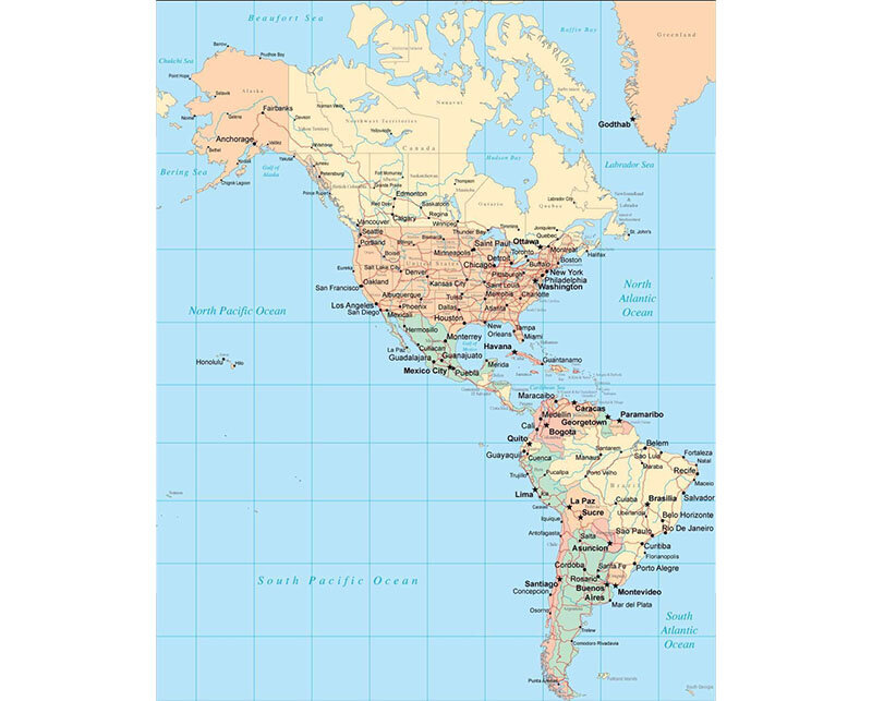
The map of America provides a scaled overview of the entire American region, which includes North America, Central America and South America. Through the continental map of America, readers can explore the distribution of countries, territories, topography, climate and borders with other regions.
Each geographical area of America comprises countries with unique geographical and cultural characteristics, detailed as follows:
- North America: This region includes three countries: Canada, the United States, Mexico and is one of the wealthiest areas in the world. Here, the mining and oil industries play a crucial role in economic development.
- Central America: This region consists of several countries, including Cuba, Costa Rica, the Bahamas, Jamaica, Panama, many others.
- South America: This area comprises 12 countries: Argentina, Chile, Peru, Venezuela, Uruguay, others, with economic development largely driven by the export of goods and natural resources.
2.5. Map of Antarctica
The map of Antarctica is an essential component of the global mapping system, representing a significant geographical area at the southernmost point of the planet. Antarctica remains one of the least explored regions on Earth. However, with the increasing focus on environmental issues and the potential for resource extraction, this continent is becoming a focal point for many countries worldwide.
Additionally, it is one of the coldest and most pristine territories on Earth, playing a crucial role in research related to climate change and the environment.
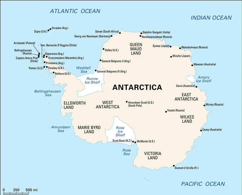
With an area of 14,200,000 km², this continent ranks fifth in the world in terms of size. The majority of its surface is covered by an ice sheet with an average thickness of 1.9 km (6,200 ft) and an average elevation of 2,835 meters (9,306 ft) above sea level. According to official regulations, Antarctica is not claimed by any nation. Instead, it hosts various research stations that conduct experiments not feasible anywhere else in the world. As of now, the largest research station in Antarctica is McMurdo Station (United States).
2.6. Map of Oceania
Oceania, also known as Australia, is a continent that stretches from east to west, covering an area of 8,725,989 square kilometers. It is recognized as the smallest continent and has the second-lowest population in the world, surpassed only by Antarctica. Nevertheless, the region boasts a stable and developed economy, renowned for its breathtaking natural landscapes.
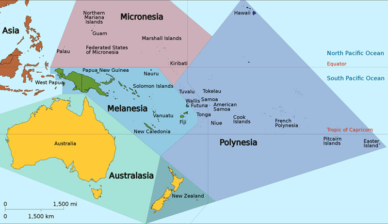
This geographical area comprises the mainland of Australasia and major islands such as New Zealand, Tasmania, New Guinea, along with thousands of smaller tropical islands in the regions of Polynesia, Micronesia and Melanesia. It is characterized by diverse topography, featuring numerous high mountain ranges, tropical rainforests, coastal regions and deserts. Economically, Australasia ranks among the major countries with the highest per capita GDP in the world. Additionally, Sydney is the largest city in the continent.
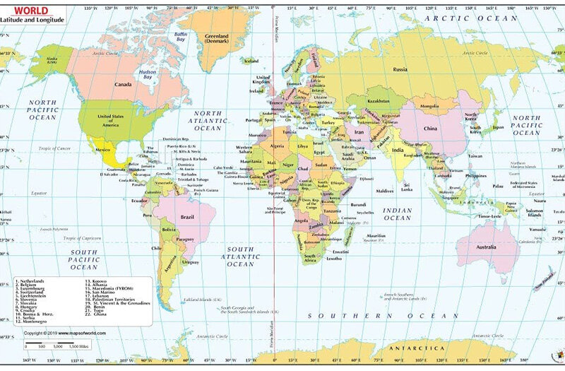
3. World Map of Countries
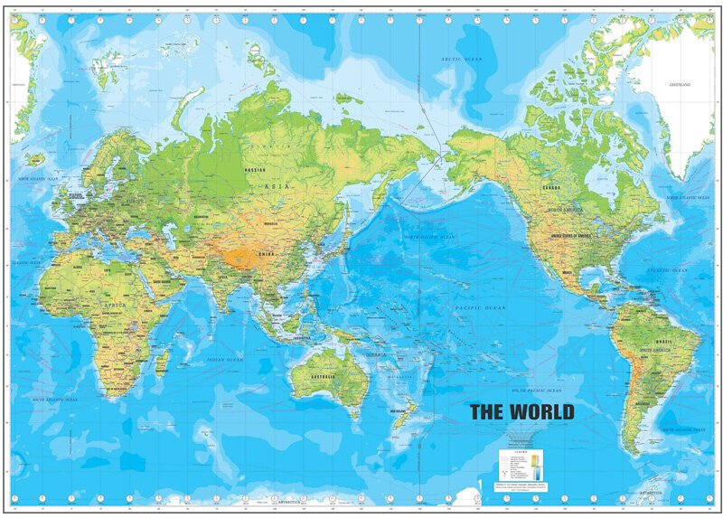
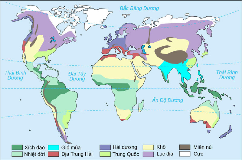
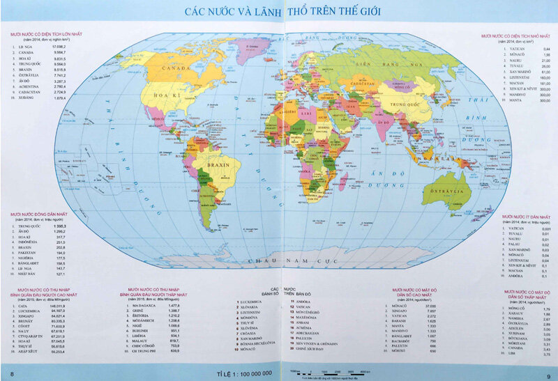
Here are some common world maps of countries used today. Take a look!
4. World map role
A world map is a “miniature” representation of the entire Earth’s surface, visually depicting countries, territories, borders, topography, population distribution, transportation networks and various other information. Accordingly, there are many different types of maps designed to serve specific purposes, including geographical maps, administrative maps, continental maps and maps of countries around the world.
In practice, world maps of countries can be illustrated in several ways, including:
- Division based on geographical boundaries, such as land and water; plateaus, plains and peninsulas; seas and oceans.
- Illustration based on political boundaries, encompassing continents and countries, island nations, territorial waters, continental shelves and exclusive economic zones.
- Depiction and interpretation of administrative maps of the world through the creation of imaginative spaces.
It can be said that geographical maps of the world are highly useful tools with wide-ranging applications in various aspects.
4.1. In education
support teaching and learning. Through different types of maps, students can grasp a wealth of information, including:
- The scale of the continents.
- The geographical location of each country.
- The distribution of topographical features.
- The population distribution in various regions.
- The location of seas and oceans.
- …
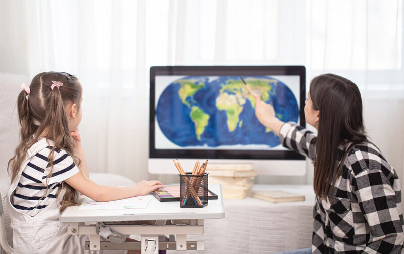
In addition to providing the latest information about current geography, a world map also helps us understand how the geographical boundaries of a country or territory have changed over different historical periods. To use maps effectively in learning, it is essential to select the appropriate map type that aligns with the content being studied. Additionally, one must identify the cardinal directions and be able to interpret the specific symbols indicated on the map.
4.2. In daily life
In everyday life, maps are widely used for various purposes, including:
- Navigating to specific locations, such as restaurants, cafes, offices, buildings.
- Studying global weather and climate, including information on low-pressure areas, high-pressure zones, wind directions and other weather factors.
- Facilitating the management and development of transportation systems through administrative world maps.
- Providing essential geographical information for urban planning and land use.
4.3. In military
Historically, maps have served as invaluable tools in military campaigns. They enable commanders to identify the precise locations of critical bases while also providing information about topography, climate characteristics, the positions of mountains, rivers and seas. This knowledge assists military forces in accurately targeting objectives, navigating troops and executing operational strategies effectively.
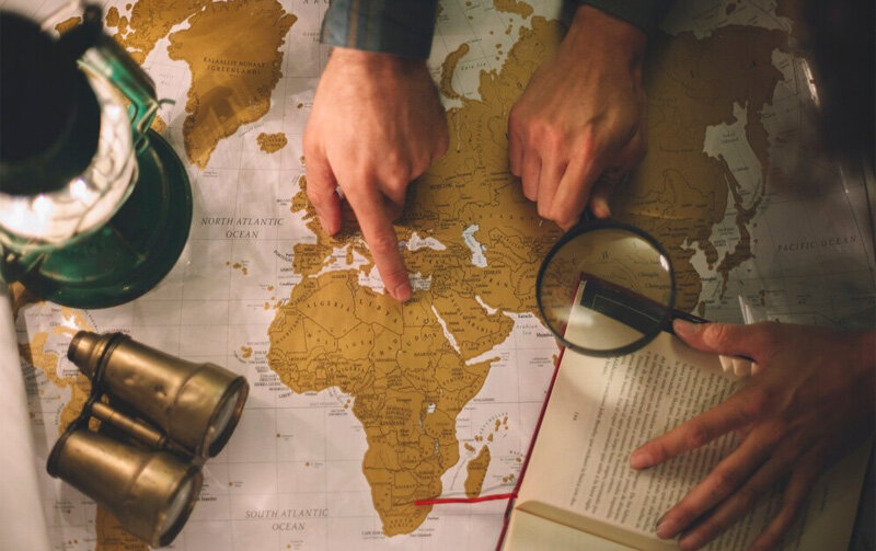
Military maps are also categorized into various types, including specialized maps, military topographic maps and aerial maps. All of these are subject to strict security measures and are utilized in the planning and execution of military operations for each nation and territory.
Maison Office has compiled the latest information regarding world maps and maps of the continents. It is evident that a world geographical map is not merely a simple illustration; it serves as a comprehensive depiction reflecting the complexity and diversity of the world we inhabit. To effectively apply maps across various fields, it is crucial to select the appropriate type of map based on your specific objectives. We hope this article has provided you with useful information!
Explore more market insights on office rentals to find the ideal location for your business
- Office for lease in District 1
- Office for lease in District 2
- Office for lease in District 3
- Office for lease in District 7
- Office for lease in Tan Binh District
- Office for lease in Binh Thanh District
- Office for lease in Phu Nhuan District
- Office for lease in Hoan Kiem District
- Office for lease in Cau Giay District
- Office for lease in Ba Dinh District
- Office for lease in Hai Ba Trung District


